11 Hidden Earth Locations Yet to Be Mapped
The Hidden and Unmapped Places of the World
There are parts of the world that remain untouched, unexplored, and even unmapped. These areas hold secrets, stories, and challenges that are often overlooked in our increasingly connected world. From remote rainforests to isolated islands and shifting coastlines, these regions highlight the limits of modern cartography and the ongoing efforts to understand and protect them.
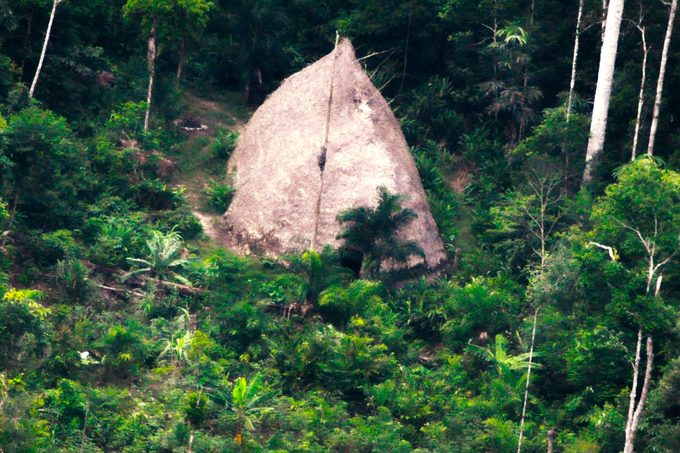
Vale do Javari, Brazil
Nestled deep within the Amazon rainforest, Vale do Javari is one of the most isolated regions on Earth. It is home to as many as 19 uncontacted indigenous tribes, who have lived in seclusion for generations. This vast area, roughly the size of Austria, covers 33,000 square miles. In 2022, the tragic murder of British journalist Dom Phillips and Brazilian activist Bruno Pereira brought global attention to the dangers faced by those working to protect this region and its people.
Slums and the Need for Accurate Mapping
In cities like Rio de Janeiro and Lagos, slums often go unnoticed on official maps. A 2022 study published in Remote Sensing emphasized the importance of mapping these informal settlements. Without accurate data, it becomes difficult for policymakers to allocate resources effectively or plan infrastructure development. This lack of representation can lead to neglect and further marginalization of vulnerable communities.
Sandy Island: A Place That Never Was
Sandy Island, once listed on marine charts and even Google Maps, was recently proven to be a myth. Located between Australia and New Caledonia, scientists discovered that the island does not exist. Experts believe that human error over the years led to its inclusion on maps, though it’s possible the island never existed at all. This case highlights how even digital tools can mislead if not verified.
Yucatan Cenotes: Exploring Underwater Wonders
The Yucatan Peninsula in Mexico is home to an extensive network of underwater caves known as cenotes. These natural sinkholes, which stretch for thousands of kilometers, have remained largely unexplored since the time of the Mayans. Photographer Klaus Thymann has been documenting these hidden wonders to raise awareness about their ecological importance. The cenotes form a critical aquifer that supports multiple ecosystems and is vital to the region's biodiversity.
Gangkhar Puensum: The Unclimbed Mountain
Gangkhar Puensum, located in Bhutan, is believed to be the highest unclimbed mountain in the world. Standing at around 10,000 feet, it remains unmapped due to spiritual beliefs held by local communities. Some consider the mountain sacred, believing it to be the dwelling place of ancient Buddhist saints and deities. While climbers may use tools like Google Earth to get a sense of the terrain, many view such practices as disrespectful to the cultural significance of the site.
Patagonia: A Region of Extreme Challenges
Patagonia, spanning southern Argentina and Chile, is known for its dramatic landscapes, including glaciers, rainforests, and rugged mountains. According to Geospatial World, the region is so remote and hostile that it is nearly impossible to map. Ice fields comparable to those in polar regions make exploration and documentation extremely difficult, posing significant challenges for researchers and cartographers.
Northern Forest Complex, Myanmar
Myanmar’s Northern Forest Complex has remained relatively untouched due to years of economic sanctions. However, recent deforestation and habitat loss threaten the region’s biodiversity. With few roads and limited access, it is challenging to assess the damage being done. As a result, the forest continues to disappear before it can be properly documented or protected.
Cape Melville, Australia
Cape Melville in Australia is often referred to as a "lost world." Surrounded by towering granite boulders, the area is inaccessible to most explorers. This natural barrier has preserved its rainforest ecosystem but also made it nearly impossible to map accurately. Scientists and conservationists continue to seek ways to study and protect this unique environment.
North Sentinel Island, India
North Sentinel Island, part of the Andaman Islands, remains one of the most isolated places on Earth. The Sentinelese people, who live there, have no contact with the outside world and reportedly resist any attempts at interaction. As a result, the island remains unmapped and unexplored, preserving its mystery and protecting its inhabitants from external influence.
Changing Coastlines and Ocean Floors
Coastlines are constantly shifting due to climate change, with rising sea levels and extreme weather events altering the landscape. Even well-mapped areas are struggling to keep up with these rapid changes. Meanwhile, the ocean floor remains one of the least understood parts of the planet. Despite covering 71% of Earth's surface, only 23% has been mapped in detail. Efforts by oceanographers aim to improve this, but the challenges of underwater exploration remain significant.
The Importance of Accurate Mapping
Mapping is more than just a tool for navigation—it plays a crucial role in understanding and protecting the natural and human environments we inhabit. Whether it’s identifying slums for aid distribution, preserving sacred sites, or tracking environmental changes, accurate maps help us make informed decisions. As technology advances, so too must our efforts to explore and document the world’s most hidden and uncharted places.
Post a Comment for "11 Hidden Earth Locations Yet to Be Mapped"
Post a Comment