Los Quetzales National Park: Your Essential Travel Guide
Introduction to Quetzal National Park
For those seeking a serene cloud forest hike and the chance to spot one of the most iconic birds in the birdwatching world, the Resplendent Quetzal, Quetzal National Park (Parque Nacional Los Quetzales) is an ideal destination. Located in the San Gerardo de Dota area, this park offers a unique blend of natural beauty and wildlife, making it a must-visit for nature lovers and bird enthusiasts.
Despite its remote location, the park has become a popular spot for travelers who are willing to navigate the logistics involved. While the experience can be rewarding, there are several things to consider before planning your visit.
Key Information About the Park
Location and Altitude
Quetzal National Park is situated near Cerro de la Muerte, approximately two hours south of San José. The park spans altitudes ranging from 2,000 to 3,000 meters (6,600 to 9,800 feet), contributing to its diverse ecosystem and unique climate.
Main Features
The park is renowned for its cloud forest hiking trails and exceptional birdwatching opportunities, particularly for spotting the elusive Resplendent Quetzal. The main entrance is located just off Route 2 (Interamericana Highway), with the closest town being San Gerardo de Dota.
Essential Details for Visitors
Entrance Fees
- Foreign visitors: $10 USD
- Children: $5 USD
- Costa Rican nationals/residents: ₡1,000
- Children (6–12): ₡500
These fees are subject to change and were last updated as of May 2025.
Ticket Booking
As of May 1st, 2025, all tickets must be pre-booked online through the SINAC website. It’s important to note that there is no cell service at the park entrance, so visitors should ensure they have their tickets ready before arriving.
Opening Hours
The park is open daily from 8:00 AM to 4:00 PM, with the last entry typically allowed around 2:00 PM. It's advisable to arrive early to maximize your chances of encountering active wildlife.
Directions to the Park
From San José
Take Route 2 south (Carretera Interamericana). After about two hours, look for a small sign indicating the park on the right. The entrance is just before the turn-off for San Gerardo de Dota if you're heading south.
From the Pacific Coast
If you're coming from Uvita, Dominical, or Manuel Antonio, take Route 34 until you reach Route 243 heading inland toward San Isidro de El General. Continue on Route 2 north (Carretera Interamericana) toward San José. You'll pass through Cerro de la Muerte, and the park entrance will be on your left shortly after the turnoff for San Gerardo de Dota.
Parking is available for free at the entrance, with a large lot offering ample space.
Vehicle Recommendations
While a 4×4 vehicle is not necessary to reach the park, it is recommended for exploring the surrounding areas, as some roads are steep and unpaved. Visitors should also avoid leaving valuable items in their vehicles, as the area is near a main highway and could be vulnerable to theft.
What to Wear and Bring
Clothing
Layering is essential due to the cold temperatures in the cloud forest. A combination of rain protection, warm layers, and waterproof shoes is recommended. Many visitors wear multiple layers, including a tank top, long-sleeve shirt, flannel, fleece, and a rain jacket.
Essentials to Carry
- Rain jacket
- Waterproof backpack
- Snacks (no food sold on-site)
- Large full water bottle
- Bug spray
- SPF 50+ sunscreen
- Pocket binoculars
- Camera or phone with zoom for bird photography
Best Time to Visit
The most popular months to visit are January through March, when the weather is drier and the trails are more accessible. This period also coincides with the peak activity of the Resplendent Quetzal, as egg-laying and incubation occur from late January through early April.
During the rainy season (August–October), visitors can expect fewer crowds but muddier conditions and heavier cloud cover.
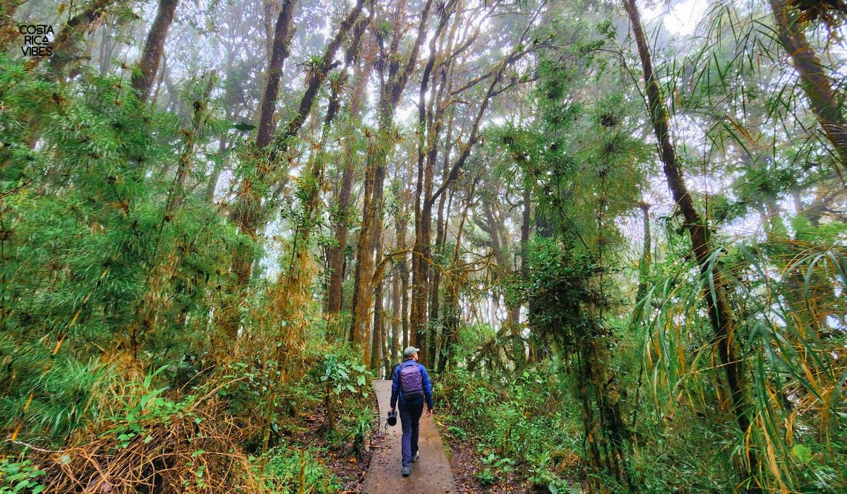
Hiking Trails
There are two marked trails in the park:
Zeldonia Trail
A shorter and more accessible trail, mostly paved with well-maintained paths. It is relatively easy, though some hilly sections and stairs may be present. The trail is 1,312 feet (400 meters) long.
Ojo de Agua Trail
A longer and more forested trail, not paved and often muddy. This trail is 1.25 miles (2 kilometers) long and offers a more rugged experience.
Both trails are linear, meaning visitors hike in and then return the same way.
Personal Experience at the Park
Visitors often find the Zeldonia Trail to be well-maintained and enjoyable, with new stairs and boardwalks. The Ojo de Agua Trail, while less impressive, may offer spots where birdwatchers can spot the Resplendent Quetzal, especially near matted-down areas along the path.
Park Background
Quetzal National Park was established on January 16, 2006, as Costa Rica’s 28th national park. Previously known as the Los Santos Forest Biological Reserve, the upgrade brought stricter protections and increased eco-tourism opportunities for nearby communities.
The park encompasses 5,021 hectares, including seasonal glacial lagoons and the headwaters of the Savegre River. It is home to a wide variety of flora and fauna, including 300 bird species, 45 mammal species, and numerous amphibians, reptiles, and insects.
Things to Do After Visiting the Park
After your visit, consider enjoying a trout lunch at Cafe Kahawa in San Gerardo de Dota. There are also several other hiking trails in the area, such as the waterfall trails, and a peaceful botanical garden called Batsu.
Accommodations Nearby
Some of the best places to stay near the park include Dantica Cloud Forest Lodge, Hotel Savegre, Lauraceas Lodge, and Las Cataratas Lodge.
In conclusion, Parque Nacional Los Quetzales is a fantastic destination for nature lovers and birdwatchers. However, if you're staying in San Gerardo de Dota, you might prefer exploring other local hikes that don’t require driving back up to the main road.
Post a Comment for "Los Quetzales National Park: Your Essential Travel Guide"
Post a Comment