Winter Storm Alerts Issued in 13 States: Snow, Ice, Extreme Cold, and Severe Flooding Expected
A Major Winter Storm Sweeps Across the U.S.
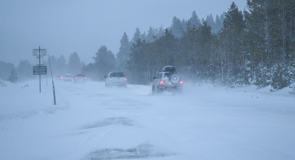
A powerful winter storm is currently affecting a large portion of the United States, prompting the National Weather Service (NWS) to issue winter storm warnings and winter weather advisories across 13 states. These alerts stretch from the Northern Plains through the Midwest and into the Northeast. The storm follows weeks of early-season snow that has already led to school closures nationwide. This ongoing weather event highlights the challenges faced by communities as they prepare for severe conditions.
States Under Winter Storm Alerts
As of Thursday morning, December 11, winter storm warnings or advisories are in effect for several states, including Montana, North Dakota, South Dakota, Minnesota, Iowa, Illinois, Indiana, Ohio, and Kentucky. Additional advisories cover northern Michigan, Pennsylvania, New York, and Vermont. These alerts indicate a mix of snow, ice, and strong winds impacting different regions as the storm system moves eastward.
The NWS is closely monitoring the situation, noting that the combination of these elements could lead to dangerous travel conditions and other hazards.
Dangerous Arctic Air Moving South
Alongside the snow and ice, a significant blast of Arctic air is moving southward, bringing record-breaking cold temperatures to the Northern Plains, Upper Mississippi Valley, Midwest, and eventually the Ohio and Tennessee Valleys. Afternoon high temperatures on Friday and Saturday are expected to be 20 to 30 degrees below average, with some areas possibly experiencing record low afternoon highs. This cold snap will also increase the risk of dangerous wind chills and refreezing moisture on untreated roads.
The NWS warns that hazardous travel conditions will persist well beyond the initial snowfall, emphasizing the need for caution and preparedness.
Snowfall Totals and Regional Impacts
The NWS predicts accumulating snow today into early Friday as a fast-moving area of low pressure moves from the Central Plains into the Ohio Valley. Forecasters expect:
- A narrow band of 2–4 inches of snow on the northern side of the storm
- Widespread 3-inch totals across much of the U.S. over the next three days
- Higher totals in Montana and parts of the Northeast, where lake-effect snow will contribute to accumulations
In the Buffalo, New York, region, snowfall could reach up to 5 inches. The NWS Buffalo warns that snow-covered roads and reduced visibility may impact the Thursday evening commute.
Ice Storm Concerns
Further west, freezing rain is causing significant issues:
- An ice storm warning in South Dakota warns of “significant icing”
- Freezing rain continues to create hazardous travel conditions in northern Montana, South Dakota, and Nebraska
- Up to one-tenth of an inch of ice is possible in parts of the Dakotas and eastern Montana
Ice accumulation also affects aviation, with the NWS noting severe icing conditions likely across Iowa, Illinois, Indiana, and Michigan’s Upper Peninsula. Delays and cancellations are possible in the hardest-hit areas.
Record Flooding and Evacuations in the Pacific Northwest
While the central and eastern U.S. deal with snow and cold, the Pacific Northwest is facing a separate emergency. Days of heavy rain, fueled by a powerful atmospheric river, have led to record flooding. Tens of thousands are under evacuation orders as major rivers surge past historic levels, including the Snohomish River, which topped its previous record crest set 35 years ago.
Washington Gov. Bob Ferguson has declared a state of emergency, warning that “lives will be at stake in the coming days.” FEMA response teams are now on the ground following reports of more than a foot of rain in some communities.
Although rain is expected to diminish later Thursday, major to catastrophic flooding impacts will continue for several days across western Washington and northwestern Oregon.
Rain, Snow, and a Mix: What’s Falling Where
As of Thursday morning:
- Montana is seeing mostly rain with some pockets of snow
- Northern Plains and Upper Midwest are dealing with freezing rain
- Northeast is experiencing a mix of snow and lake-effect enhancement
Radar imagery and windy.com animations show the storm already in progress, with more precipitation expected as the system deepens and shifts east. The NWS says the storm’s final chapter may play out in the mid-Atlantic, where 1–2 inches of snow are possible along the I-95 corridor between Philadelphia and Washington, D.C., as the system weakens but spreads wintry precipitation farther south.
Forecast confidence will tighten as the storm evolves, but meteorologists expect shifting precipitation types and hazardous travel conditions into the weekend.
Post a Comment for "Winter Storm Alerts Issued in 13 States: Snow, Ice, Extreme Cold, and Severe Flooding Expected"
Post a Comment